
Phelps topographic map
Interactive map
Click on the map to display elevation.
About this map
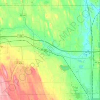
Name: Phelps topographic map, elevation, terrain.
Location: Phelps, Ontario County, New York, United States (42.90076 -77.13349 43.01319 -76.96335)
Average elevation: 174 m
Minimum elevation: 120 m
Maximum elevation: 267 m
Other topographic maps
Click on a map to view its topography, its elevation and its terrain.
Port Gibson
United States > New York > Ontario County > Town of Manchester
Port Gibson, Town of Manchester, Ontario County, New York, 14537, United States
Average elevation: 156 m
Town of Victor
United States > New York > Ontario County
Town of Victor, Ontario County, New York, United States
Average elevation: 202 m
Hill Cumorah
United States > New York > Ontario County > Town of Manchester
Hill Cumorah, Town of Manchester, Ontario County, New York, 14504, United States
Average elevation: 182 m
Town of Canandaigua
United States > New York > Ontario County
Town of Canandaigua, Ontario County, New York, 14424, United States
Average elevation: 290 m
Town of Gorham
United States > New York > Ontario County
Town of Gorham, Ontario County, New York, United States
Average elevation: 286 m