
Mound topographic map
Click on the map to display elevation.
About this map
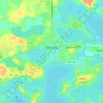
Name: Mound topographic map, elevation, terrain.
Location: Mound, Hennepin County, Minnesota, 55364, United States (44.91684 -93.69352 44.95294 -93.62794)
Average elevation: 290 m
Minimum elevation: 279 m
Maximum elevation: 318 m
Other topographic maps
Click on a map to view its topography, its elevation and its terrain.
Elm Creek Park (Maple Grove Arboretum)
United States > Minnesota > Hennepin County > Maple Grove
Average elevation: 278 m
Pond-Dakota Mission Park
United States > Minnesota > Hennepin County > Bloomington
Average elevation: 235 m
Mississippi River East Channel
United States > Minnesota > Hennepin County > Minneapolis
Average elevation: 255 m
Mississippi River
United States > Minnesota > Hennepin County > Minneapolis
The uppermost lock and dam on the Upper Mississippi River is the Upper St. Anthony Falls Lock and Dam in Minneapolis. Above the dam, the river's elevation is 799 feet (244 m). Below the dam, the river's elevation is 750 feet (230 m). This 49-foot (15 m) drop is the largest of all the Mississippi River locks…
Average elevation: 256 m
Eden Prairie
United States > Minnesota > Hennepin County > Eden Prairie > Eden Prairie
Average elevation: 267 m
Minnehaha Falls
United States > Minnesota > Hennepin County > Minneapolis
Fortunately for the generations to come, in 1883 the state legislature created the Minneapolis Board of Park Commissioners. The board began by acquiring park land near today's downtown Minneapolis. Their choice to hire noted landscape architect Horace Cleveland was fortunate. Cleveland was hired by the Board…
Average elevation: 249 m