Geolocate

Tenterden topographic map

Click on the map to display elevation.

About this map

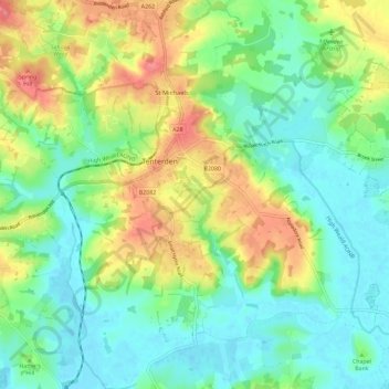
Name: Tenterden topographic map, elevation, terrain.

Location: Tenterden, Ashford, Kent, England, United Kingdom (51.02750 0.64253 51.09999 0.75704)

Average elevation: 28 m

Minimum elevation: -1 m

Maximum elevation: 78 m

Other topographic maps

Click on a map to view its topography, its elevation and its terrain.

Hamstreet

United Kingdom > England > Kent > Ashford

Average elevation: 22 m

Hinxhill

United Kingdom > England > Kent > Ashford

Average elevation: 51 m

Gear up for your next adventure:

👟Trail Running Shoes - Agile footwear for fast-paced topographic exploration
🥘Camping Cookware Set - Compact nesting pots and pans for trail cooking
🪑Insulated Seat Pad - Protect your seat from cold rocks and wet logs
💧Reusable Water Bottle - Durable water bottles for hydration on trails
👟Leg Gaiters - Keep debris, mud, and snow out of your boots

As an Amazon Associate, this site earns from qualifying purchases at no extra cost to you.