
Sandy Point topographic map
Click on the map to display elevation.
About this map
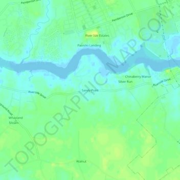
Name: Sandy Point topographic map, elevation, terrain.
Location: Sandy Point, Wicomico County, Maryland, 21826, United States (38.31512 -75.68132 38.35512 -75.64132)
Average elevation: 7 m
Minimum elevation: -3 m
Maximum elevation: 17 m
Other topographic maps
Click on a map to view its topography, its elevation and its terrain.
Salisbury
United States > Maryland > Wicomico County
According to the United States Census Bureau, the city has a total area of 13.87 square miles (35.92 km2), of which 13.40 square miles (34.71 km2) is land and 0.47 square miles (1.22 km2) is water. The city has a varying elevation of 17 to 45 feet (5.2 to 13.7 m) above sea level.
Average elevation: 12 m
Newtwon - Camden Tot Lot
United States > Maryland > Wicomico County > Salisbury
Average elevation: 8 m
Salisbury
United States > Maryland > Wicomico County
According to the United States Census Bureau, the city has a total area of 13.87 square miles (35.92 km2), of which 13.40 square miles (34.71 km2) is land and 0.47 square miles (1.22 km2) is water. The city has a varying elevation of 17 to 45 feet (5.2 to 13.7 m) above sea level.
Average elevation: 12 m