Geolocate

Swansea Point topographic map

Click on the map to display elevation.

About this map

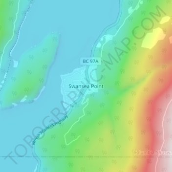
Name: Swansea Point topographic map, elevation, terrain.

Location: Swansea Point, Area E (Eagle River Valley), Columbia-Shuswap Regional District, British Columbia, Canada (50.74702 -119.02725 50.78702 -118.98725)

Average elevation: 565 m

Minimum elevation: 334 m

Maximum elevation: 1,299 m

Other topographic maps

Click on a map to view its topography, its elevation and its terrain.

Mara Lake

Canada > British Columbia > Columbia-Shuswap Regional District > Area E (Eagle River Valley) > Swansea Point

The lake is 35.3 kilometres (21.9 mi) long. The surface area is about 1,943 hectares (4,800 acres) and elevation is 338 metres (1,109 ft) above sea level. The mean and maximum depth is 18 metres (59 ft).

Average elevation: 826 m

Gear up for your next adventure:

🥾Mountain Hiking Boots - High-traction boots for rocky terrain
🥾Hiking Boots - Sturdy boots providing ankle support and traction on rugged trails
🧴First Aid Kit - Essential first aid supplies for outdoor emergencies
🌡️Emergency Mylar Blankets - Compact thermal protection for unexpected nights outdoors
🥾Hiking Leggings - Comfortable leggings for outdoor activities

As an Amazon Associate, this site earns from qualifying purchases at no extra cost to you.