
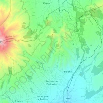
San Juan de Pastocalle topographic map
Interactive map
Click on the map to display elevation.
About this map
Name: San Juan de Pastocalle topographic map, elevation, terrain.
Location: San Juan de Pastocalle, Latacunga, Cotopaxi, Ecuador (-0.76017 -78.71571 -0.59718 -78.58182)
Average elevation: 3,465 m
Minimum elevation: 2,979 m
Maximum elevation: 5,205 m
Other topographic maps
Click on a map to view its topography, its elevation and its terrain.
Belisario Quevedo
Ecuador > Cotopaxi > Latacunga
Belisario Quevedo, Latacunga, Cotopaxi, Ecuador
Average elevation: 2,945 m
Pastocalle
Ecuador > Cotopaxi > Latacunga > Latacunga
Pastocalle, Latacunga, Cotopaxi, 050108, Ecuador
Average elevation: 2,851 m
El Salvario
Ecuador > Cotopaxi > Latacunga > Latacunga > El Salvario
El Salvario, Latacunga, Cotopaxi, 050108, Ecuador
Average elevation: 2,818 m