
Pastocalle topographic map
Interactive map
Click on the map to display elevation.
About this map
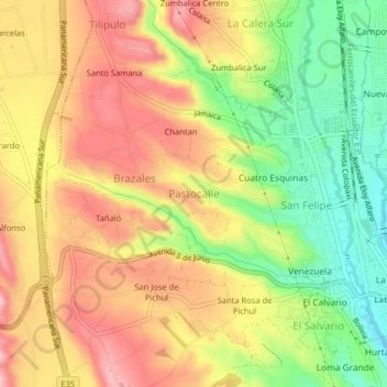
Name: Pastocalle topographic map, elevation, terrain.
Location: Pastocalle, Latacunga, Cotopaxi, 050108, Ecuador (-0.94227 -78.66391 -0.90227 -78.62391)
Average elevation: 2,851 m
Minimum elevation: 2,749 m
Maximum elevation: 2,940 m
Other topographic maps
Click on a map to view its topography, its elevation and its terrain.
El Salvario
Ecuador > Cotopaxi > Latacunga > Latacunga > El Salvario
El Salvario, Latacunga, Cotopaxi, 050108, Ecuador
Average elevation: 2,818 m