Geolocate

Oslo topographic map

Click on the map to display elevation.

About this map

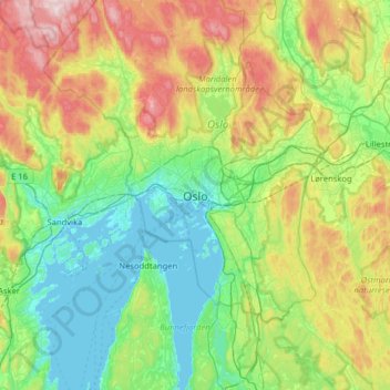
Name: Oslo topographic map, elevation, terrain.

Location: Oslo, 0026, Norway (59.75333 10.57897 60.07333 10.89897)

Average elevation: 186 m

Minimum elevation: -1 m

Maximum elevation: 638 m

Other topographic maps

Click on a map to view its topography, its elevation and its terrain.

Lutvann

Norway > Oslo

Average elevation: 257 m

Oslo

Norway > Oslo

Average elevation: 225 m

Royal Palace

Norway > Oslo

Average elevation: 31 m

Oslo

Norway > Oslo

Average elevation: 225 m

Akerselva

Norway > Oslo

The Akerselva or Akerselven (English: The Aker River) is a river which flows through Oslo, Norway. It starts at Maridalsvannet in Oslomarka, and traverses the boroughs of Nordre Aker, Sagene, Grünerløkka, central Oslo and Grønland, finally ending at Paulsenkaien and Oset in Bjørvika. The river is…

Average elevation: 165 m

Oslo

Norway > Oslo

Average elevation: 225 m

Oslo

Norway > Oslo

Average elevation: 225 m

Oslo

Norway > Oslo

Average elevation: 225 m

Oslo

Norway > Oslo

Average elevation: 225 m

Ullern

Norway > Oslo

Average elevation: 58 m

Oslo

Norway > Oslo

Average elevation: 225 m

Huk

Norway > Oslo

Average elevation: 4 m

Gear up for your next adventure:

🧥Softshell Hiking Jacket - The perfect balance of wind protection and breathability
🧣Merino Neck Gaiter - Protects against wind, sun, and cold at high altitudes
🔋Solar Power Bank - Keep your GPS and devices charged during long outdoor trips
🛏️Camping Sleeping Mat - Comfortable mats for sleeping outdoors
👟Sport Hiking Sandals - Breathable footwear for water crossings and camp rest

As an Amazon Associate, this site earns from qualifying purchases at no extra cost to you.