Geolocate

Oslo topographic map

Click on the map to display elevation.

About this map

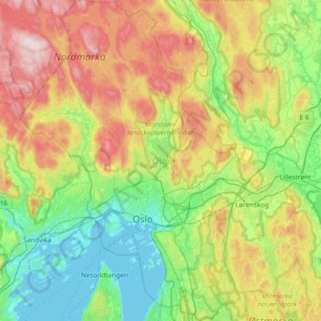
Name: Oslo topographic map, elevation, terrain.

Location: Oslo, Norway (59.80931 10.48917 60.13511 10.95139)

Average elevation: 225 m

Minimum elevation: -1 m

Maximum elevation: 682 m

Other topographic maps

Click on a map to view its topography, its elevation and its terrain.

Oslo

Norway > Oslo

Average elevation: 186 m

Telemark

Norway > Oslo

Average elevation: 10 m

Stensrud

Norway > Oslo

Average elevation: 169 m

Huk

Norway > Oslo

Average elevation: 4 m

Prekestolen

Norway > Oslo

Average elevation: 427 m

Hardanger

Norway > Oslo

Average elevation: 8 m

Barlindåsen

Norway > Oslo

Average elevation: 318 m

Gear up for your next adventure:

❄️Traction Ice Cleats - Slip-on spikes for icy trails and winter hiking
🥾Trail Running Boots - Durable shoes designed for trail running
💡Portable Camping Lamp - Rechargeable lamp for campsite lighting
🥾Hiking Leggings - Comfortable leggings for outdoor activities
🥾Trekking Boots - Durable boots for long-distance trekking

As an Amazon Associate, this site earns from qualifying purchases at no extra cost to you.