Geolocate

Knik Arm topographic map

Click on the map to display elevation.

About this map

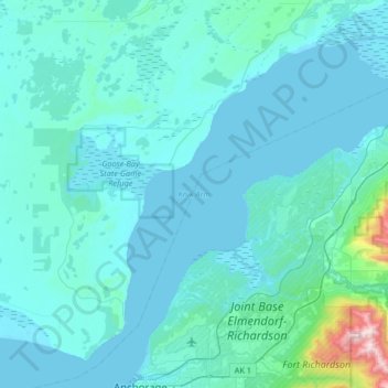
Name: Knik Arm topographic map, elevation, terrain.

Location: Knik Arm, Anchorage, Alaska, United States (61.22146 -149.98519 61.52379 -149.33007)

Average elevation: 72 m

Minimum elevation: -2 m

Maximum elevation: 1,254 m

Other topographic maps

Click on a map to view its topography, its elevation and its terrain.

Girdwood

United States > Alaska > Anchorage

Average elevation: 181 m

Wilson Village

United States > Alaska > Anchorage > Anchorage

Average elevation: 48 m

Anchorage

United States > Alaska > Anchorage

Average elevation: 124 m

Powder Ridge

United States > Alaska > Anchorage

Average elevation: 89 m

Chugach Meadows

United States > Alaska > Anchorage > Anchorage

Average elevation: 46 m

Redoubt

United States > Alaska > Anchorage

Average elevation: 49 m

Oceanview

United States > Alaska > Anchorage

Average elevation: 30 m

South Yuyanq’ Ch’ex

United States > Alaska > Anchorage

Average elevation: 1,071 m

Gear up for your next adventure:

🔨Vehicle Emergency Tool - Safety tool for remote road trips to trailheads
🧥Softshell Hiking Jacket - The perfect balance of wind protection and breathability
🚲Handlebar Phone Mount - View topographic-map.com live while cycling
🧥Thermal Layer - Insulating layer for cold outdoor conditions
🧶550 Survival Paracord - Versatile utility cord for emergency repairs and rigging

As an Amazon Associate, this site earns from qualifying purchases at no extra cost to you.