Geolocate

Hage topographic map

Click on the map to display elevation.

About this map
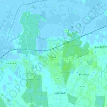
Name: Hage topographic map, elevation, terrain.

Location: Hage, Samtgemeinde Hage, Landkreis Aurich, Lower Saxony, 26524, Germany (53.57694 7.26842 53.63353 7.34436)

Average elevation: 1 m

Minimum elevation: -4 m

Maximum elevation: 7 m

Other topographic maps

Click on a map to view its topography, its elevation and its terrain.

Greetsiel

Germany > Lower Saxony > Landkreis Aurich

Average elevation: -1 m

Arle

Germany > Lower Saxony > Landkreis Aurich > Großheide

Average elevation: 2 m

Arle

Germany > Lower Saxony > Landkreis Aurich > Großheide

Average elevation: 2 m

Gear up for your next adventure:

🩹Moleskin Blister Pads - Direct protection for painful foot pressure points
🧭GPS Handheld Device - Reliable GPS navigation for outdoor adventures
🔋Solar Power Bank - Keep your GPS and devices charged during long outdoor trips
🥫Freeze-Dried Meals - Lightweight, high-calorie nutrition for multi-day treks
🍽️Titanium Camping Spork - Ultralight and indestructible eating utensil

As an Amazon Associate, this site earns from qualifying purchases at no extra cost to you.