Geolocate

Sitio Pandan topographic map

Click on the map to display elevation.

About this map

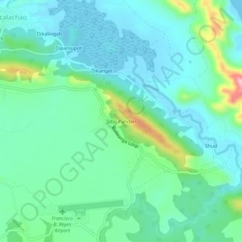
Name: Sitio Pandan topographic map, elevation, terrain.

Location: Sitio Pandan, Coron, Palawan, Mimaropa, 5316, Philippines (12.11591 120.08590 12.15591 120.12590)

Average elevation: 45 m

Minimum elevation: 0 m

Maximum elevation: 202 m

Other topographic maps

Click on a map to view its topography, its elevation and its terrain.

Malaroroy Island

Philippines > Palawan > Coron > Bulog

Average elevation: 2 m

Uson Island

Philippines > Palawan > Coron > Bancuan

Average elevation: 14 m

Coron Island

Philippines > Palawan > Coron

Average elevation: 37 m

Gear up for your next adventure:

🔥Emergency Fire Starter - Reliable ignition source for all weather conditions
🥾Lightweight Hiking Boots - Boots for comfort and mobility on long hikes
🧴Waterproofing Spray - Restore the DWR coating on jackets and tents
🥾Waterproof Hiking Shoes - Durable shoes for wet and rugged trails
🧥Waterproof Hiking Jacket - Protect yourself from rain and wind while hiking

As an Amazon Associate, this site earns from qualifying purchases at no extra cost to you.