Geolocate

Coron Island topographic map

Click on the map to display elevation.

About this map

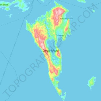
Name: Coron Island topographic map, elevation, terrain.

Location: Coron Island, Coron, Palawan, Mimaropa, Philippines (11.80740 120.19171 11.98721 120.27674)

Average elevation: 37 m

Minimum elevation: -4 m

Maximum elevation: 568 m

Other topographic maps

Click on a map to view its topography, its elevation and its terrain.

Tagumpay

Philippines > Palawan > Coron

Average elevation: 30 m

Malaroroy Island

Philippines > Palawan > Coron > Bulog

Average elevation: 2 m

Galo

Philippines > Palawan > Coron > Decalachao

Average elevation: 38 m

Twin Lagoon

Philippines > Palawan > Coron

Average elevation: 106 m

Sitio Pandan

Philippines > Palawan > Coron

Average elevation: 45 m

Gear up for your next adventure:

🩹Compact First Aid Kit - Pre-packed essentials for common trail injuries
🥾All-Terrain Hiking Boots - Versatile boots for varied hiking conditions
🧰Emergency Multi-Tool - Compact multi-tool for outdoor survival
🌡️Emergency Mylar Blankets - Compact thermal protection for unexpected nights outdoors
🏃Hydration Running Vest - Carry water and maps close to your body for speed

As an Amazon Associate, this site earns from qualifying purchases at no extra cost to you.