
Make a donation
Gear up for your next adventure:
As an Amazon Associate, this site earns from qualifying purchases at no extra cost to you.
Numão topographic map
Click on the map to display elevation.
Make a donation
Gear up for your next adventure:
As an Amazon Associate, this site earns from qualifying purchases at no extra cost to you.
About this map
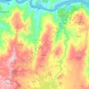
Name: Numão topographic map, elevation, terrain.
Location: Numão, Vila Nova de Foz Côa, Guarda, 5155-638, Portugal (41.06558 -7.30909 41.14500 -7.24421)
Average elevation: 453 m
Minimum elevation: 103 m
Maximum elevation: 802 m
Make a donation
Gear up for your next adventure:
As an Amazon Associate, this site earns from qualifying purchases at no extra cost to you.
Other topographic maps
Click on a map to view its topography, its elevation and its terrain.
Miradouro de Horta do Douro
Portugal > Guarda > Vila Nova de Foz Coa > Horta > Senhora da Estrada
Average elevation: 563 m
Make a donation
Gear up for your next adventure:
As an Amazon Associate, this site earns from qualifying purchases at no extra cost to you.