Geolocate

Gagangir topographic map

Click on the map to display elevation.

About this map

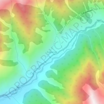
Name: Gagangir topographic map, elevation, terrain.

Location: Gagangir, Kangan, Ganderbal district, Jammu and Kashmir, India (34.26833 75.17455 34.30833 75.21455)

Average elevation: 2,795 m

Minimum elevation: 2,229 m

Maximum elevation: 3,822 m

Other topographic maps

Click on a map to view its topography, its elevation and its terrain.

Kangan

India > Jammu and Kashmir > Kangan

Average elevation: 3,335 m

Gear up for your next adventure:

🔭Compact Binoculars - Lightweight optics for scouting trails and wildlife
💡LED Headlamp - Hands-free illumination for night hiking and camping
🧥Thermal Fleece Jacket - Versatile insulation for changing mountain temperatures
🔦LED Headlamp - Hands-free lighting for early morning starts or late finishes
🧶550 Survival Paracord - Versatile utility cord for emergency repairs and rigging

As an Amazon Associate, this site earns from qualifying purchases at no extra cost to you.