Geolocate

Kangan topographic map

Click on the map to display elevation.

About this map

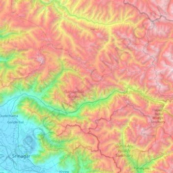
Name: Kangan topographic map, elevation, terrain.

Location: Kangan, Ganderbal District, Jammu and Kashmir, India (34.16056 74.77496 34.46375 75.49617)

Average elevation: 3,335 m

Minimum elevation: 1,581 m

Maximum elevation: 5,416 m

Other topographic maps

Click on a map to view its topography, its elevation and its terrain.

Gagangir

India > Jammu and Kashmir > Kangan

Average elevation: 2,795 m

Gear up for your next adventure:

🧢Hiking Hat - Sun-protective and breathable hats for long treks
👖Convertible Hiking Pants - Zip-off legs to adapt to changing weather conditions
🧦Hiking Socks - Moisture-wicking and comfortable socks for long hikes
🦟Insect Repellent - Keep mosquitoes and black flies away in wooded areas
🧳Compression Sacks - Maximize space in your backpack by shrinking gear

As an Amazon Associate, this site earns from qualifying purchases at no extra cost to you.