
Teno topographic map
Click on the map to display elevation.
About this map
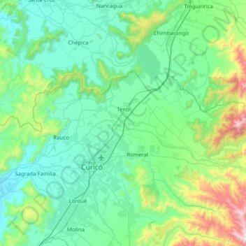
Name: Teno topographic map, elevation, terrain.
Average elevation: 417 m
Minimum elevation: 119 m
Maximum elevation: 1,952 m
Other topographic maps
Click on a map to view its topography, its elevation and its terrain.
Cascada Las Buitreras
Chile > Región del Maule > Provincia de Curicó > Curicó
Average elevation: 788 m
La Primavera
Chile > Región del Maule > Provincia de Curicó > Sagrada Familia > Las Delicias
Average elevation: 142 m
Convento Viejo
Chile > Región del Maule > Provincia de Curicó > Curicó > Convento Viejo
Average elevation: 182 m
El Heraldo
Chile > Región del Maule > Provincia de Curicó > Teno > El Heraldo
Average elevation: 370 m
Los Cristales
Chile > Región del Maule > Provincia de Curicó > Curicó > Los Cristales - El Prado > Los Cristales
Average elevation: 250 m
La Puntilla de Zapallar
Chile > Región del Maule > Provincia de Curicó > Curicó > La Puntilla de Zapallar
Average elevation: 358 m
Pichingal
Chile > Región del Maule > Provincia de Curicó > Molina > Pichingal
Average elevation: 298 m
Buena Paz
Chile > Región del Maule > Provincia de Curicó > Molina > Buena Paz
Average elevation: 359 m
La Chipana Huemul
Chile > Región del Maule > Provincia de Curicó > Teno > La Chipana Huemul
Average elevation: 362 m
San Jorge de Romeral
Chile > Región del Maule > Provincia de Curicó > Molina > San Jorge de Romeral
Average elevation: 331 m
Condominio Cerro Los Cristales
Chile > Región del Maule > Provincia de Curicó > Curicó
Average elevation: 286 m
Parroncillo
Chile > Región del Maule > Provincia de Curicó > Sagrada Familia > Santa Rosa
Average elevation: 193 m
Los Castaños
Chile > Región del Maule > Provincia de Curicó > Curicó > Los Castaños
Average elevation: 277 m
Callejón El Socavón
Chile > Región del Maule > Provincia de Curicó > Romeral > Callejón El Socavón
Average elevation: 475 m
Santa Adriana
Chile > Región del Maule > Provincia de Curicó > Sagrada Familia > Lo Valdivia
Average elevation: 171 m
Cordillerilla
Chile > Región del Maule > Provincia de Curicó > Curicó > La Palmera
Average elevation: 350 m