
Parque Inglés topographic map
Click on the map to display elevation.
About this map
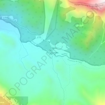
Name: Parque Inglés topographic map, elevation, terrain.
Average elevation: 1,239 m
Minimum elevation: 976 m
Maximum elevation: 2,086 m
Other topographic maps
Click on a map to view its topography, its elevation and its terrain.
Parque Nacional Radal Siete Tazas
Chile > Región del Maule > Provincia de Curicó > Molina
Average elevation: 1,616 m
Reserva Nacional Radal Siete Tazas
Chile > Región del Maule > Provincia de Curicó > Molina
Average elevation: 1,059 m