
Make a donation
Gear up for your next adventure:
As an Amazon Associate, this site earns from qualifying purchases at no extra cost to you.
Lindern (Oldenburg) topographic map
Click on the map to display elevation.
Make a donation
Gear up for your next adventure:
As an Amazon Associate, this site earns from qualifying purchases at no extra cost to you.
About this map
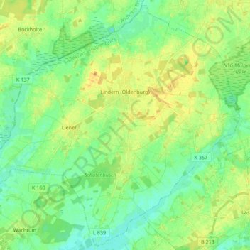
Name: Lindern (Oldenburg) topographic map, elevation, terrain.
Average elevation: 33 m
Minimum elevation: 23 m
Maximum elevation: 46 m
Make a donation
Gear up for your next adventure:
As an Amazon Associate, this site earns from qualifying purchases at no extra cost to you.
Other topographic maps
Click on a map to view its topography, its elevation and its terrain.
Hoheging
Deutschland > Niedersachsen > Landkreis Cloppenburg > Emstek
Die Bauerschaft Hoheging gehört zum Dreiländereck "HoKeBü", das aus den Gemeinden Hoheging, Kellerhöhe (gehört zur Stadt Cloppenburg) und Bürgermoor (gehört zur Gemeinde Garrel) besteht.
Average elevation: 39 m
Edewechterdamm
Deutschland > Niedersachsen > Landkreis Cloppenburg > Friesoythe
Average elevation: 7 m
Neumarkhausen
Deutschland > Niedersachsen > Landkreis Cloppenburg > Friesoythe
Average elevation: 29 m
Make a donation
Gear up for your next adventure:
As an Amazon Associate, this site earns from qualifying purchases at no extra cost to you.
Make a donation
Gear up for your next adventure:
As an Amazon Associate, this site earns from qualifying purchases at no extra cost to you.
Markhausen
Deutschland > Niedersachsen > Landkreis Cloppenburg > Friesoythe
Ahrensdorf | Altenoythe | Augustendorf | Edewechterdamm | Ellerbrock | Friesoythe | Gehlenberg | Heinfelde | Kampe | Kamperfehn | Markhausen | Mehrenkamp | Neuscharrel | Neuvrees | Pehmertange | Schlingshöhe | Schwaneburg | Schwaneburgermoor | Thüle
Average elevation: 22 m
Make a donation
Gear up for your next adventure:
As an Amazon Associate, this site earns from qualifying purchases at no extra cost to you.
Neuscharrel
Deutschland > Niedersachsen > Landkreis Cloppenburg > Friesoythe
Ahrensdorf | Altenoythe | Augustendorf | Edewechterdamm | Ellerbrock | Friesoythe | Gehlenberg | Heinfelde | Kampe | Kamperfehn | Markhausen | Mehrenkamp | Neuscharrel | Neuvrees | Pehmertange | Schlingshöhe | Schwaneburg | Schwaneburgermoor | Thüle
Average elevation: 8 m
Marienwallfahrtsort Bethen
Deutschland > Niedersachsen > Landkreis Cloppenburg > Cloppenburg
Ambühren | Bethen | Cloppenburg (Kernbereich) | Emstekerfeld | Galgenmoor | Kellerhöhe | Staatsforsten | Stapelfeld | Sternbusch | Schmertheim | Vahren
Average elevation: 44 m
Make a donation
Gear up for your next adventure:
As an Amazon Associate, this site earns from qualifying purchases at no extra cost to you.
Make a donation
Gear up for your next adventure:
As an Amazon Associate, this site earns from qualifying purchases at no extra cost to you.
Schelmkappe
Deutschland > Niedersachsen > Landkreis Cloppenburg > Löningen > Böen
Average elevation: 24 m
Ambühren
Deutschland > Niedersachsen > Landkreis Cloppenburg > Cloppenburg
Ambühren | Bethen | Cloppenburg (Kernbereich) | Emstekerfeld | Galgenmoor | Kellerhöhe | Staatsforsten | Stapelfeld | Sternbusch | Schmertheim | Vahren
Average elevation: 40 m
Make a donation
Gear up for your next adventure:
As an Amazon Associate, this site earns from qualifying purchases at no extra cost to you.
Pirgo
Deutschland > Niedersachsen > Landkreis Cloppenburg > Friesoythe > Altenoythe
Average elevation: 8 m
Make a donation
Gear up for your next adventure:
As an Amazon Associate, this site earns from qualifying purchases at no extra cost to you.
Make a donation
Gear up for your next adventure:
As an Amazon Associate, this site earns from qualifying purchases at no extra cost to you.
Hegel
Deutschland > Niedersachsen > Landkreis Cloppenburg > Lindern (Oldenburg)
Average elevation: 36 m
Make a donation
Gear up for your next adventure:
As an Amazon Associate, this site earns from qualifying purchases at no extra cost to you.
Farwick
Deutschland > Niedersachsen > Landkreis Cloppenburg > Löningen > Neuenbunnen
Average elevation: 26 m
Make a donation
Gear up for your next adventure:
As an Amazon Associate, this site earns from qualifying purchases at no extra cost to you.
Neuvrees
Deutschland > Niedersachsen > Landkreis Cloppenburg > Friesoythe > Neuvrees
Average elevation: 14 m
Altenoythe
Deutschland > Niedersachsen > Landkreis Cloppenburg > Friesoythe > Altenoythe
Ahrensdorf | Altenoythe | Augustendorf | Edewechterdamm | Ellerbrock | Friesoythe | Gehlenberg | Heinfelde | Kampe | Kamperfehn | Markhausen | Mehrenkamp | Neuscharrel | Neuvrees | Pehmertange | Schlingshöhe | Schwaneburg | Schwaneburgermoor | Thüle
Average elevation: 9 m
Make a donation
Gear up for your next adventure:
As an Amazon Associate, this site earns from qualifying purchases at no extra cost to you.
Hollenermoor
Deutschland > Niedersachsen > Landkreis Cloppenburg > Saterland > Hollenermoor
Average elevation: 5 m
Lodbergen
Deutschland > Niedersachsen > Landkreis Cloppenburg > Löningen > Lodbergen
Average elevation: 29 m
Mittelsten Thüle
Deutschland > Niedersachsen > Landkreis Cloppenburg > Friesoythe > Mittelsten Thüle
Average elevation: 18 m
Make a donation
Gear up for your next adventure:
As an Amazon Associate, this site earns from qualifying purchases at no extra cost to you.
Halen
Deutschland > Niedersachsen > Landkreis Cloppenburg
Halen ist ein Ortsteil im Norden der Gemeinde Emstek, Landkreis Cloppenburg, Oldenburger Münsterland und mit einer Fläche von 2.375 Hektar und 1.666 Einwohnern (Stand: 31. März 2016) das größte Dorf der Gemeinde. Sein Gebiet grenzt im Norden an Hoheging und Beverbruch, im Osten an Ahlhorn und Garthe, im…
Average elevation: 52 m
Oldendorf (Lastrup)
Deutschland > Niedersachsen > Landkreis Cloppenburg > Lastrup
Average elevation: 33 m