Geolocate

Hinode topographic map

Click on the map to display elevation.

About this map

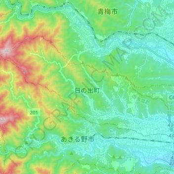
Name: Hinode topographic map, elevation, terrain.

Location: Hinode, Nishitama District, Tokyo, Japan (35.73146 139.16304 35.78919 139.28469)

Average elevation: 228 m

Minimum elevation: 102 m

Maximum elevation: 634 m

Other topographic maps

Click on a map to view its topography, its elevation and its terrain.

Mount Takao

Japan > Tokyo

Average elevation: 399 m

Iō Island

Japan > Tokyo

Average elevation: 27 m

Mount Takao

Japan > Tokyo

Average elevation: 399 m

Iō Island

Japan > Tokyo

Average elevation: 27 m

Iō Island

Japan > Tokyo

Average elevation: 27 m

Tokyo International Airport

Japan > Tokyo

Average elevation: 2 m

Mount Atago

Japan > Tokyo

Average elevation: 60 m

Mount Nokogiri

Japan > Tokyo

Average elevation: 836 m

Gear up for your next adventure:

🥽Outdoor Goggles - Protective eyewear for outdoor activities
🚲Bike Repair Kit - Essential tools for on-trail mechanical issues
🧊Portable Cooler - Keep food and drinks cold during outdoor adventures
🍽️Titanium Camping Spork - Ultralight and indestructible eating utensil
🕶️Polarized Sunglasses - Reduces glare from snow and water at high elevations

As an Amazon Associate, this site earns from qualifying purchases at no extra cost to you.