
Make a donation
Gear up for your next adventure:
As an Amazon Associate, this site earns from qualifying purchases at no extra cost to you.
Frettes topographic map
Click on the map to display elevation.
Make a donation
Gear up for your next adventure:
As an Amazon Associate, this site earns from qualifying purchases at no extra cost to you.
About this map
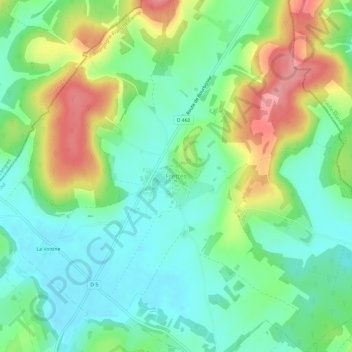
Name: Frettes topographic map, elevation, terrain.
Average elevation: 309 m
Minimum elevation: 272 m
Maximum elevation: 377 m
Make a donation
Gear up for your next adventure:
As an Amazon Associate, this site earns from qualifying purchases at no extra cost to you.
Other topographic maps
Click on a map to view its topography, its elevation and its terrain.
Make a donation
Gear up for your next adventure:
As an Amazon Associate, this site earns from qualifying purchases at no extra cost to you.
Make a donation
Gear up for your next adventure:
As an Amazon Associate, this site earns from qualifying purchases at no extra cost to you.
Make a donation
Gear up for your next adventure:
As an Amazon Associate, this site earns from qualifying purchases at no extra cost to you.
Champagney
Frankrijk > Bourgondië-Franche-Comté > Haute-Saône
De oppervlakte van Champagney bedroeg op 1 januari 2022 36,71 vierkante kilometer; de bevolkingsdichtheid was toen 100,1 inwoners per km². Het stuwmeer bassin de Champagney ligt op een hoogte van 411 meter en heeft een oppervlakte van 107 ha.
Average elevation: 433 m
Make a donation
Gear up for your next adventure:
As an Amazon Associate, this site earns from qualifying purchases at no extra cost to you.
Make a donation
Gear up for your next adventure:
As an Amazon Associate, this site earns from qualifying purchases at no extra cost to you.
Make a donation
Gear up for your next adventure:
As an Amazon Associate, this site earns from qualifying purchases at no extra cost to you.
Betoncourt-Saint-Pancras
Frankrijk > Bourgondië-Franche-Comté > Haute-Saône > Betoncourt-Saint-Pancras
Average elevation: 288 m
Make a donation
Gear up for your next adventure:
As an Amazon Associate, this site earns from qualifying purchases at no extra cost to you.
Fouvent-Saint-Andoche
Frankrijk > Bourgondië-Franche-Comté > Haute-Saône > Fouvent-Saint-Andoche
Average elevation: 271 m