
Make a donation
Gear up for your next adventure:
As an Amazon Associate, this site earns from qualifying purchases at no extra cost to you.
Vars topographic map
Click on the map to display elevation.
Make a donation
Gear up for your next adventure:
As an Amazon Associate, this site earns from qualifying purchases at no extra cost to you.
About this map
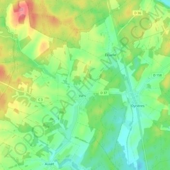
Name: Vars topographic map, elevation, terrain.
Average elevation: 240 m
Minimum elevation: 201 m
Maximum elevation: 307 m
Make a donation
Gear up for your next adventure:
As an Amazon Associate, this site earns from qualifying purchases at no extra cost to you.
Other topographic maps
Click on a map to view its topography, its elevation and its terrain.
L'Enclose
France > Bourgogne – Franche-Comté > Haute-Saône > Servance-Miellin
Average elevation: 566 m
Le Tertre
France > Bourgogne – Franche-Comté > Haute-Saône > Amont-et-Effreney
Average elevation: 504 m
Saint-Valère
France > Bourgogne – Franche-Comté > Haute-Saône > Port-sur-Saône
Average elevation: 245 m
Make a donation
Gear up for your next adventure:
As an Amazon Associate, this site earns from qualifying purchases at no extra cost to you.
La Roche d'Amont
France > Bourgogne – Franche-Comté > Haute-Saône > Haut-du-Them
Average elevation: 590 m
La Vieille Voie
France > Bourgogne – Franche-Comté > Haute-Saône > Corravillers
Average elevation: 593 m