
South Ribble topographic map
Click on the map to display elevation.
About this map
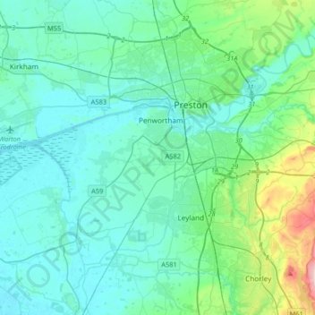
Name: South Ribble topographic map, elevation, terrain.
Location: South Ribble, Lancashire, England, United Kingdom (53.67132 -2.87092 53.78283 -2.54555)
Average elevation: 40 m
Minimum elevation: 0 m
Maximum elevation: 270 m
Other topographic maps
Click on a map to view its topography, its elevation and its terrain.
Coppull
United Kingdom > England > Lancashire > Chorley
The settlement has an Anglo Saxon name describing its topography derived from the Old English copp a hill top and hyll a hill. The township was variously recorded as Cophull and Cophulle in 1277, Copphull in 1351, Copthull in 1374 and Coppull from 1444.
Average elevation: 79 m
Belthorn Reservoir (disused)
United Kingdom > England > Lancashire > Hyndburn > Oswaldtwistle
Average elevation: 291 m
Farington Moss
United Kingdom > England > Lancashire > South Ribble > Farington Moss
Average elevation: 36 m