
Thorn Hill topographic map
Interactive map
Click on the map to display elevation.
About this map
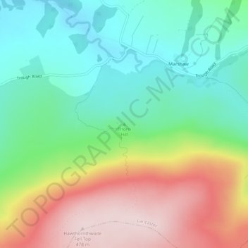
Name: Thorn Hill topographic map, elevation, terrain.
Average elevation: 269 m
Minimum elevation: 138 m
Maximum elevation: 478 m
Other topographic maps
Click on a map to view its topography, its elevation and its terrain.
Cockerham
United Kingdom > England > Lancashire > Lancaster
Cockerham, Lancaster, Lancashire, England, United Kingdom
Average elevation: 8 m
Galgate
United Kingdom > England > Lancashire > Lancaster > Galgate
Galgate, Lancaster, Lancashire, England, LA2 0RP, United Kingdom
Average elevation: 43 m
Heysham
United Kingdom > England > Lancashire > Lancaster
Heysham, Lancaster, Lancashire, England, LA3 2DS, United Kingdom
Average elevation: 4 m