
Elizabethton topographic map
Interactive map
Click on the map to display elevation.
About this map
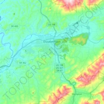
Name: Elizabethton topographic map, elevation, terrain.
Average elevation: 567 m
Minimum elevation: 433 m
Maximum elevation: 1,016 m
The elevation at Elizabethton Municipal Airport is 1,593 feet (486 m) ASL (the highest point of elevation in Carter County is at Roan Mountain with an elevation of 6,285 feet (1,916 m) ASL), and the airport is located on the eastern side of the city along State Highway 91 Stoney Creek Exit. Elizabethton is also connected to larger commercial, shuttle, and cargo flights out of Tri-Cities Regional Airport northwest of Johnson City.
Other topographic maps
Click on a map to view its topography, its elevation and its terrain.
Elizabethton
United States > Tennessee > Carter County > Elizabethton > Elizabethton
Elizabethton, Carter County, Tennessee, 37643, United States
Average elevation: 527 m
Roan Mountain
United States > Tennessee > Carter County
Roan Mountain, Carter County, East Tennessee, Tennessee, United States
Average elevation: 1,418 m
Pine Crest
United States > Tennessee > Carter County
Pine Crest, Carter County, East Tennessee, Tennessee, United States
Average elevation: 515 m
Tolley Town
United States > Tennessee > Carter County
Tolley Town, Carter County, East Tennessee, Tennessee, United States
Average elevation: 896 m
Winner
United States > Tennessee > Carter County
Winner, Carter County, East Tennessee, Tennessee, United States
Average elevation: 614 m
Roan Mountain State Park
United States > Tennessee > Carter County > Roan Mountain
Roan Mountain State Park, Roan Mountain, Carter County, East Tennessee, Tennessee, United States
Average elevation: 988 m
Watauga Lake
United States > Tennessee > Carter County
Watauga Lake, Carter County, Tennessee, 37640, United States
Average elevation: 755 m
Central
United States > Tennessee > Carter County
Central, Carter County, East Tennessee, Tennessee, United States
Average elevation: 489 m
Roan Mountain
United States > Tennessee > Carter County
Roan Mountain, Carter County, East Tennessee, Tennessee, 37687, United States
Average elevation: 926 m
Elk Mills
United States > Tennessee > Carter County
Elk Mills, Carter County, Tennessee, United States
Average elevation: 749 m
Dogtown
United States > Tennessee > Carter County
Dogtown, Carter County, Tennessee, United States
Average elevation: 617 m
Jane Bald
United States > Tennessee > Carter County
Jane Bald, Carter County, East Tennessee, Tennessee, United States
Average elevation: 1,573 m
Watauga
United States > Tennessee > Carter County
Watauga, Carter County, East Tennessee, Tennessee, United States
Average elevation: 465 m
Hunter
United States > Tennessee > Carter County
Hunter, Carter County, Tennessee, United States
Average elevation: 706 m
Milligan
United States > Tennessee > Carter County > Elizabethton > Milligan
Milligan, Elizabethton, Carter County, Tennessee, 37605, United States
Average elevation: 508 m
Hampton
United States > Tennessee > Carter County
Hampton, Carter County, East Tennessee, Tennessee, 37658, United States
Average elevation: 674 m
Valley Park
United States > Tennessee > Carter County > Elizabethton > Valley Park
Valley Park, Elizabethton, Carter County, Tennessee, 37643, United States
Average elevation: 515 m