Geolocate

Dugspur topographic map

Click on the map to display elevation.

About this map

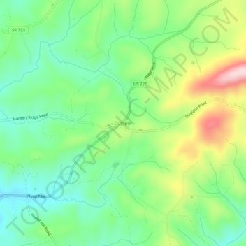
Name: Dugspur topographic map, elevation, terrain.

Location: Dugspur, Carroll County, Virginia, 24325, United States (36.79791 -80.62979 36.83791 -80.58979)

Average elevation: 794 m

Minimum elevation: 695 m

Maximum elevation: 977 m

Other topographic maps

Click on a map to view its topography, its elevation and its terrain.

Cana

United States > Virginia > Carroll County > Cana

Average elevation: 422 m

Hillsville

United States > Virginia > Carroll County

Average elevation: 769 m

Fancy Gap

United States > Virginia > Carroll County

Average elevation: 865 m

Fancy Gap

United States > Virginia > Carroll County

Average elevation: 865 m

Hillsville

United States > Virginia > Carroll County

Average elevation: 769 m

Gear up for your next adventure:

🧴Outdoor Sunscreen - High SPF protection for high-altitude UV exposure
🦟Insect Repellent - Keep mosquitoes and black flies away in wooded areas
🏕️Camping Hammock - Integrated protection for sleeping between trees
🚲Heavy Duty Bike Lock - Secure your bike at the trailhead or during stops
🧢Beanie Hat - Keep your head warm in cold weather

As an Amazon Associate, this site earns from qualifying purchases at no extra cost to you.