Geolocate

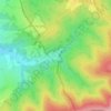
Rajhrad topographic map

Click on the map to display elevation.

About this map

Name: Rajhrad topographic map, elevation, terrain.

Location: Rajhrad, okres Brno-venkov, South Moravian Region, 664 61, Czechia (49.06675 16.56509 49.10427 16.63319)

Average elevation: 211 m

Minimum elevation: 182 m

Maximum elevation: 281 m

Other topographic maps

Click on a map to view its topography, its elevation and its terrain.
Hnízdo

Czechia > South Moravian Region

Average elevation: 232 m

Vápenky

Czechia > South Moravian Region > Nová Lhota

Average elevation: 578 m

Gear up for your next adventure:

🛏️Sleeping Bag - Warm and compact sleeping bags for outdoor camping
🧥Waterproof Hiking Jacket - Protect yourself from rain and wind while hiking
🥫Freeze-Dried Meals - Lightweight, high-calorie nutrition for multi-day treks
🧴Bear Spray Holster - Quick-access carry for essential Canadian wilderness safety
🧊Insulated Water Bottle - Keeps drinks cold in summer and prevents freezing in winter

As an Amazon Associate, this site earns from qualifying purchases at no extra cost to you.