Geolocate

Cheboygan topographic map

Click on the map to display elevation.

About this map

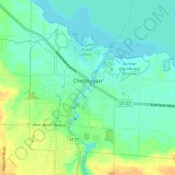
Name: Cheboygan topographic map, elevation, terrain.

Location: Cheboygan, Cheboygan County, Michigan, United States (45.61982 -84.49849 45.67005 -84.43288)

Average elevation: 181 m

Minimum elevation: 171 m

Maximum elevation: 201 m

Other topographic maps

Click on a map to view its topography, its elevation and its terrain.

Tower

United States > Michigan > Cheboygan County

Average elevation: 232 m

Afton

United States > Michigan > Cheboygan County

Average elevation: 236 m

Alverno

United States > Michigan > Cheboygan County

Average elevation: 202 m

Birchwood

United States > Michigan > Cheboygan County

Average elevation: 189 m

Elmhurst

United States > Michigan > Cheboygan County

Average elevation: 184 m

Freedom

United States > Michigan > Cheboygan County

Average elevation: 190 m

Grand View

United States > Michigan > Cheboygan County

Average elevation: 189 m

Long Point

United States > Michigan > Cheboygan County

Average elevation: 186 m

Rondo

United States > Michigan > Cheboygan County

Average elevation: 260 m

Silver Beach

United States > Michigan > Cheboygan County

Average elevation: 192 m

Topinabee

United States > Michigan > Cheboygan County

Average elevation: 201 m

Wildwood

United States > Michigan > Cheboygan County

Average elevation: 248 m

Aloha

United States > Michigan > Cheboygan County

Average elevation: 185 m

Gear up for your next adventure:

🦌Outdoor Trail Camera - Monitor wildlife activity near your favorite spots
🧦Crew Hiking Socks - Comfortable socks for long-distance hikes
🧥Thermal Fleece Jacket - Versatile insulation for changing mountain temperatures
🥾Trail Hiking Socks - Comfortable socks to prevent blisters and fatigue
🥾All-Terrain Hiking Boots - Versatile boots for varied hiking conditions

As an Amazon Associate, this site earns from qualifying purchases at no extra cost to you.