
Make a donation
Gear up for your next adventure:
As an Amazon Associate, this site earns from qualifying purchases at no extra cost to you.
Luznice topographic map
Click on the map to display elevation.
Make a donation
Gear up for your next adventure:
As an Amazon Associate, this site earns from qualifying purchases at no extra cost to you.
About this map
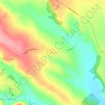
Name: Luznice topographic map, elevation, terrain.
Average elevation: 276 m
Minimum elevation: 213 m
Maximum elevation: 350 m
Make a donation
Gear up for your next adventure:
As an Amazon Associate, this site earns from qualifying purchases at no extra cost to you.
Other topographic maps
Click on a map to view its topography, its elevation and its terrain.
Vrbica
Serbia > Central Serbia > Sumadija Administrative District > Arandjelovac Municipality
Average elevation: 373 m
Donja Satornja
Serbia > Central Serbia > Sumadija Administrative District > Topola Municipality
Average elevation: 350 m
Bozurnja
Serbia > Central Serbia > Sumadija Administrative District > Topola Municipality
Average elevation: 233 m
Make a donation
Gear up for your next adventure:
As an Amazon Associate, this site earns from qualifying purchases at no extra cost to you.
Make a donation
Gear up for your next adventure:
As an Amazon Associate, this site earns from qualifying purchases at no extra cost to you.
Borac
Serbia > Central Serbia > Sumadija Administrative District
Borač is a village in the municipality of Knić, Serbia. It is at an elevation of 1,093 ft (333 m). According to the 2011 census, the village has a population of 590 inhabitants.
Average elevation: 453 m
Belosavci
Serbia > Central Serbia > Sumadija Administrative District > Topola Municipality
Average elevation: 174 m
Gornja Tresnjevica
Serbia > Central Serbia > Sumadija Administrative District > Arandjelovac Municipality
Average elevation: 385 m
Make a donation
Gear up for your next adventure:
As an Amazon Associate, this site earns from qualifying purchases at no extra cost to you.
Brzan
Serbia > Central Serbia > Sumadija Administrative District > Batocina Municipality
Average elevation: 142 m
Progoreoci
Serbia > Central Serbia > Sumadija Administrative District > Arandjelovac Municipality
Average elevation: 262 m
Mali Mirasevac
Serbia > Central Serbia > Sumadija Administrative District > Raca Municipality
Average elevation: 148 m
Gruza Lake
Serbia > Central Serbia > Sumadija Administrative District > Knic Municipality
New spatial plan was proposed in 2011, but was never adopted. It included elevation of the water level and enlargement of the lake, but the residents of the bank villages protested, fearing they will end up being flooded. In March 2022, the government decided to make a new spatial plan for the area, which…
Average elevation: 306 m
Make a donation
Gear up for your next adventure:
As an Amazon Associate, this site earns from qualifying purchases at no extra cost to you.
City of Kragujevac
Serbia > Central Serbia > Sumadija Administrative District
Average elevation: 320 m