Geolocate

St Lawrence topographic map

Click on the map to display elevation.

About this map

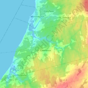
Name: St Lawrence topographic map, elevation, terrain.

Location: St Lawrence, Prince County, Prince Edward Island, Canada (46.82611 -64.28602 46.87912 -64.15688)

Average elevation: 20 m

Minimum elevation: -3 m

Maximum elevation: 61 m

Prince County trails, hiking, mountain biking, running and outdoor activities

Other topographic maps

Click on a map to view its topography, its elevation and its terrain.

Gear up for your next adventure:

Lightweight Backpacking Tent - Compact tent for efficient hiking trips
🔭Compact Binoculars - Lightweight optics for scouting trails and wildlife
🧣Evaporative Cooling Towel - Beat the heat during intense summer climbs
🧥Insulated Jacket - Keep warm in cold outdoor conditions
🌬️Windproof Camp Stove - Efficient cooking even on exposed mountain peaks

As an Amazon Associate, this site earns from qualifying purchases at no extra cost to you.