
Centro topographic map
Click on the map to display elevation.
About this map
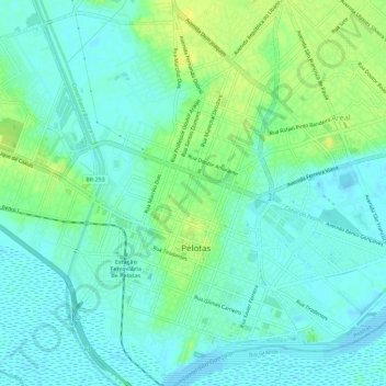
Name: Centro topographic map, elevation, terrain.
Average elevation: 8 m
Minimum elevation: -2 m
Maximum elevation: 21 m
Other topographic maps
Click on a map to view its topography, its elevation and its terrain.
Colônia Maciel
Brasil > Rio Grande do Sul > Aglomeração Urbana do Sul > Pelotas > Rincão da Cruz > Colônia Maciel
Average elevation: 200 m
Balneário dos Prazeres
Brasil > Rio Grande do Sul > Aglomeração Urbana do Sul > Pelotas
Average elevation: 7 m
Associação Rural de Pelotas
Brasil > Rio Grande do Sul > Aglomeração Urbana do Sul > Pelotas
Average elevation: 15 m
Praça Domingos Rodrigues
Brasil > Rio Grande do Sul > Aglomeração Urbana do Sul > Pelotas
Average elevation: 5 m
Pelotas
Brasil > Rio Grande do Sul > Aglomeração Urbana do Sul > Pelotas
Por estar situada numa planície costeira, a área urbana do município situa-se em baixa altitude, com, em média, 7 metros acima do nível do mar. O interior do município está sobre um planalto com elevações médias, denominado Serras de Sudeste, com cerros de ondulações moderadas e cobertos com…
Average elevation: 18 m
Canal Santa Bárbara
Brasil > Rio Grande do Sul > Aglomeração Urbana do Sul > Pelotas
Average elevation: 11 m
Arroio Pelotas
Brasil > Rio Grande do Sul > Aglomeração Urbana do Sul > Pelotas
Average elevation: 9 m