
Pelotas topographic map
Click on the map to display elevation.
Pelotas
As it is situated on a plain near the ocean, the urban area lies on a low elevation, being, on average, 7 meters (23 ft) above sea level. The interior of the municipality is on a plateau called Serras de Sudeste (Southeastern Mountain Ranges). Consequently, the altitude in Pelotas' rural area reaches 429 meters (1,407.4 ft) in the Quilombo district.
About this map
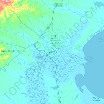
Name: Pelotas topographic map, elevation, terrain.
Average elevation: 18 m
Minimum elevation: -2 m
Maximum elevation: 287 m