
Make a donation
Gear up for your next adventure:
As an Amazon Associate, this site earns from qualifying purchases at no extra cost to you.
Robledo topographic map
Click on the map to display elevation.
Make a donation
Gear up for your next adventure:
As an Amazon Associate, this site earns from qualifying purchases at no extra cost to you.
Robledo
Robledo liegt in der nördlichen Berglandschaft der Sierra de Alcaraz, dem nördlichen Ausläufer der Betischen Kordillere. Der Ort befindet sich in ca. 50 km (Fahrtstrecke) westsüdwestlich der Provinzhauptstadt Albacete einer Höhe von ca. 1000 m. Das Klima im Winter ist gemäßigt, im Sommer dagegen warm; die geringen Niederschlagsmengen fallen – mit Ausnahme der nahezu regenlosen Sommermonate – verteilt übers ganze Jahr.
Make a donation
Gear up for your next adventure:
As an Amazon Associate, this site earns from qualifying purchases at no extra cost to you.
About this map
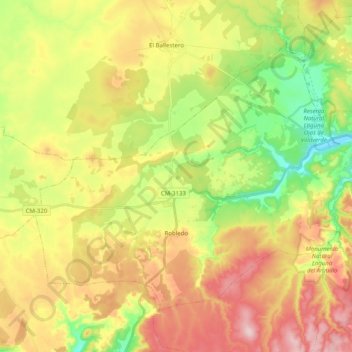
Name: Robledo topographic map, elevation, terrain.
Location: Robledo, Kastilien-La Mancha, Spanien (38.72383 -2.52976 38.84292 -2.32945)
Average elevation: 1,015 m
Minimum elevation: 899 m
Maximum elevation: 1,144 m
Make a donation
Gear up for your next adventure:
As an Amazon Associate, this site earns from qualifying purchases at no extra cost to you.
Other topographic maps
Click on a map to view its topography, its elevation and its terrain.
Make a donation
Gear up for your next adventure:
As an Amazon Associate, this site earns from qualifying purchases at no extra cost to you.
Make a donation
Gear up for your next adventure:
As an Amazon Associate, this site earns from qualifying purchases at no extra cost to you.