Geolocate

Kippel topographic map

Click on the map to display elevation.

About this map

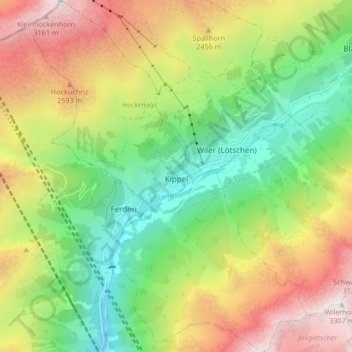
Name: Kippel topographic map, elevation, terrain.

Location: Kippel, Westlich Raron, Wallis, 3917, Switzerland (46.37089 7.73645 46.42838 7.80260)

Average elevation: 2,079 m

Minimum elevation: 1,226 m

Maximum elevation: 3,266 m

Other topographic maps

Click on a map to view its topography, its elevation and its terrain.

Goppenstein

Switzerland > Wallis > Westlich Raron

Average elevation: 1,923 m

Chistehorn

Switzerland > Wallis > Westlich Raron > Niedergesteln

Average elevation: 2,239 m

Ta

Switzerland > Wallis > Westlich Raron > Unterbäch > Unterbäch VS

Average elevation: 1,592 m

Grosshorn

Switzerland > Wallis > Westlich Raron > Blatten

Average elevation: 3,073 m

Lauchernalp

Switzerland > Wallis > Westlich Raron

Average elevation: 1,956 m

Gear up for your next adventure:

🥾Hiking Leggings - Comfortable leggings for outdoor activities
Camping Tent - Weather-resistant tents suitable for 2 to 6 people
Lightweight Backpacking Tent - Compact tent for efficient hiking trips
💧Reusable Water Bottle - Durable water bottles for hydration on trails
🥾Waterproof Hiking Boots - Boots keeping your feet dry in wet conditions

As an Amazon Associate, this site earns from qualifying purchases at no extra cost to you.