
Thank you for supporting this site ❤️
Make a donation
Make a donation
Gear up for your next adventure:
As an Amazon Associate, this site earns from qualifying purchases at no extra cost to you.
Grosshorn topographic map
Click on the map to display elevation.
Thank you for supporting this site ❤️
Make a donation
Make a donation
Gear up for your next adventure:
As an Amazon Associate, this site earns from qualifying purchases at no extra cost to you.
About this map
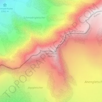
Name: Grosshorn topographic map, elevation, terrain.
Location: Grosshorn, Blatten, Westlich Raron, Wallis, 3919, Switzerland (46.48693 7.91003 46.48703 7.91013)
Average elevation: 3,073 m
Minimum elevation: 2,155 m
Maximum elevation: 3,794 m
Thank you for supporting this site ❤️
Make a donation
Make a donation
Gear up for your next adventure:
As an Amazon Associate, this site earns from qualifying purchases at no extra cost to you.