Geolocate

Seymour topographic map

Click on the map to display elevation.

About this map

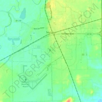
Name: Seymour topographic map, elevation, terrain.

Location: Seymour, Jackson County, Indiana, United States (38.90911 -85.92623 38.98212 -85.83462)

Average elevation: 177 m

Minimum elevation: 163 m

Maximum elevation: 206 m

Other topographic maps

Click on a map to view its topography, its elevation and its terrain.

Spraytown

United States > Indiana > Jackson County

Average elevation: 222 m

Norman

United States > Indiana > Jackson County

Average elevation: 257 m

Gear up for your next adventure:

🪜Heavy Duty Carabiners - Multi-use clips for securing gear to your backpack
🛁Quick-Dry Microfiber Towel - Space-saving towel that dries rapidly on the move
Bushcraft Tarp - Versatile emergency shelter or gear protection
🧢Sun Hat - Wide-brim hat for sun protection
🥾Hiking Shorts - Breathable shorts suitable for summer hikes

As an Amazon Associate, this site earns from qualifying purchases at no extra cost to you.