Geolocate

Spraytown topographic map

Click on the map to display elevation.

About this map

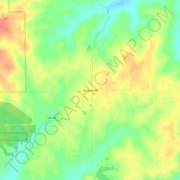
Name: Spraytown topographic map, elevation, terrain.

Location: Spraytown, Jackson County, Indiana, United States (38.99422 -86.09998 39.03422 -86.05998)

Average elevation: 222 m

Minimum elevation: 191 m

Maximum elevation: 255 m

Other topographic maps

Click on a map to view its topography, its elevation and its terrain.

Medora

United States > Indiana > Jackson County

Average elevation: 164 m

Seymour

United States > Indiana > Jackson County

Average elevation: 177 m

Seymour

United States > Indiana > Jackson County

Average elevation: 177 m

Gear up for your next adventure:

🧴Waterproofing Spray - Restore the DWR coating on jackets and tents
🛏️Camping Sleeping Mat - Comfortable mats for sleeping outdoors
👖Convertible Hiking Pants - Zip-off legs to adapt to changing weather conditions
🧴Outdoor Sunscreen - High SPF protection for high-altitude UV exposure
🩹Compact First Aid Kit - Pre-packed essentials for common trail injuries

As an Amazon Associate, this site earns from qualifying purchases at no extra cost to you.