Geolocate

Drew Park topographic map

Click on the map to display elevation.

About this map
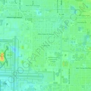
Name: Drew Park topographic map, elevation, terrain.

Location: Drew Park, Tampa, Hillsborough County, Florida, 33607, United States (27.96391 -82.53315 28.00391 -82.49315)

Average elevation: 13 m

Minimum elevation: 3 m

Maximum elevation: 31 m

Other topographic maps

Click on a map to view its topography, its elevation and its terrain.
Carrollwood

United States > Florida > Hillsborough County > Tampa

Carrollwood is located at 28.1 degrees north, 82.5 degrees west (28.0523, -82.4858). The elevation for the community is 39 feet (12 m) above sea level.

Average elevation: 16 m

Gear up for your next adventure:

💧Filtered Water Bottle - Safe drinking water on the go
🎒Fully Waterproof Backpack - Total protection for photography gear and electronics
💧Collapsible Water Bottle - Space-saving water bottle for outdoor activities
🔭Outdoor Binoculars - Lightweight binoculars for birdwatching and hiking
🔦LED Flashlight - Powerful and long-lasting flashlight for camping and emergencies

As an Amazon Associate, this site earns from qualifying purchases at no extra cost to you.