Geolocate

Mirasol topographic map

Click on the map to display elevation.

About this map

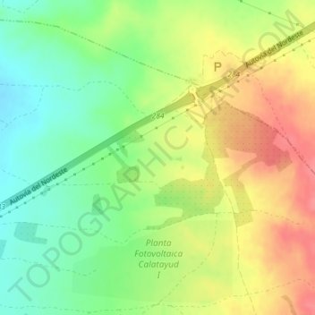
Name: Mirasol topographic map, elevation, terrain.

Location: Mirasol, Calatorao, Valdejalón, Zaragoza, Aragon, Spain (41.52187 -1.25623 41.54187 -1.23623)

Average elevation: 409 m

Minimum elevation: 375 m

Maximum elevation: 445 m

Gear up for your next adventure:

🔭Compact Monocular - One-handed bird watching and trail spotting
🔦LED Headtorch - Bright and durable light for night activities
🥫Freeze-Dried Meals - Lightweight, high-calorie nutrition for multi-day treks
🥾Trail Running Boots - Durable shoes designed for trail running
👟Trail Running Shoes - Agile footwear for fast-paced topographic exploration

As an Amazon Associate, this site earns from qualifying purchases at no extra cost to you.