Geolocate

Layman topographic map

Click on the map to display elevation.

About this map

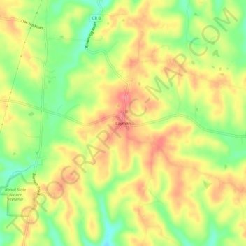
Name: Layman topographic map, elevation, terrain.

Location: Layman, Washington County, Ohio, 45724, United States (39.38341 -81.74430 39.42341 -81.70430)

Average elevation: 261 m

Minimum elevation: 219 m

Maximum elevation: 294 m

Other topographic maps

Click on a map to view its topography, its elevation and its terrain.

Marietta

United States > Ohio > Washington County

Average elevation: 215 m

Duck Creek

United States > Ohio > Washington County > Marietta

Average elevation: 242 m

Beverly

United States > Ohio > Washington County

Average elevation: 215 m

Marietta

United States > Ohio > Washington County

Average elevation: 215 m

Duck Creek

United States > Ohio > Washington County > Marietta

Average elevation: 242 m

Lowell

United States > Ohio > Washington County

Average elevation: 222 m

Belpre

United States > Ohio > Washington County

Average elevation: 206 m

Gear up for your next adventure:

🏕️Camping Hammock - Integrated protection for sleeping between trees
Backpacking Tent - Lightweight tent for long-distance hiking trips
📷Outdoor Action Camera - Capture high-elevation views and rugged adventures
🎒Hiking Daypack - Lightweight and durable backpacks for day trips and excursions
🪜Heavy Duty Carabiners - Multi-use clips for securing gear to your backpack

As an Amazon Associate, this site earns from qualifying purchases at no extra cost to you.