Geolocate

Lowell topographic map

Click on the map to display elevation.

About this map

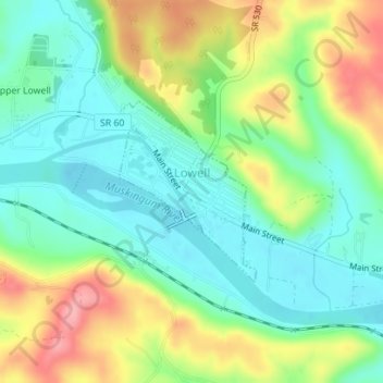
Name: Lowell topographic map, elevation, terrain.

Location: Lowell, Washington County, Ohio, United States (39.52208 -81.51293 39.53485 -81.50036)

Average elevation: 222 m

Minimum elevation: 180 m

Maximum elevation: 293 m

Other topographic maps

Click on a map to view its topography, its elevation and its terrain.

Layman

United States > Ohio > Washington County

Average elevation: 261 m

Little Hocking

United States > Ohio > Washington County

Average elevation: 202 m

Constitution

United States > Ohio > Washington County

Average elevation: 216 m

Barlow

United States > Ohio > Washington County

Average elevation: 242 m

Little Hocking

United States > Ohio > Washington County

Average elevation: 202 m

Beckett

United States > Ohio > Washington County

Average elevation: 233 m

Gear up for your next adventure:

🚑Survival Whistle - Signal for help across long distances in mountains
🍽️Titanium Camping Spork - Ultralight and indestructible eating utensil
🧰Survival Kit - Essential gear for emergencies in the wilderness
🦶Anti-Blister Balm - Prevents friction and hotspots during long ascents
🌬️Windproof Camp Stove - Efficient cooking even on exposed mountain peaks

As an Amazon Associate, this site earns from qualifying purchases at no extra cost to you.