
Durg topographic map
Interactive map
Click on the map to display elevation.
About this map
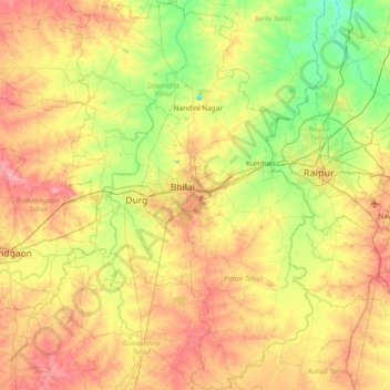
Name: Durg topographic map, elevation, terrain.
Location: Durg, Chhattisgarh, India (20.85031 81.14466 21.54485 81.62513)
Average elevation: 295 m
Minimum elevation: 255 m
Maximum elevation: 347 m
Other topographic maps
Click on a map to view its topography, its elevation and its terrain.
Kawardha
India > Chhattisgarh > Kawardha Tahsil
Kawardha is located at 22°01′N 81°15′E / 22.02°N 81.25°E / 22.02; 81.25. The total area is 798 square miles (2,070 km2). The state consists of hill and forest. It has an average elevation of 353 metres (1,158 ft).
Average elevation: 350 m
Sukma
India > Chhattisgarh > Sukma Tahsil
It is located at 18°24′0″N 81°40′0″E / 18.40000°N 81.66667°E / 18.40000; 81.66667 at an elevation of 210 m above MSL.
Average elevation: 219 m
Bhilai
India > Chhattisgarh > Durg Tahsil
Bhilai lies at 21.21°N 81.38°E in Central India at an elevation of 297m above sea level on the banks of the Shivnath river, a tributary of the river Mahanadi. It covers an area of 341 km2 (132 sq mi).
Average elevation: 292 m