
Make a donation
Gear up for your next adventure:
As an Amazon Associate, this site earns from qualifying purchases at no extra cost to you.
Rosans topographic map
Click on the map to display elevation.
Make a donation
Gear up for your next adventure:
As an Amazon Associate, this site earns from qualifying purchases at no extra cost to you.
About this map
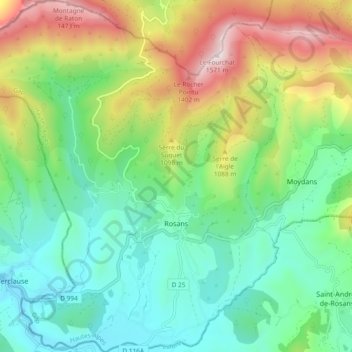
Name: Rosans topographic map, elevation, terrain.
Average elevation: 857 m
Minimum elevation: 524 m
Maximum elevation: 1,550 m
Make a donation
Gear up for your next adventure:
As an Amazon Associate, this site earns from qualifying purchases at no extra cost to you.
Other topographic maps
Click on a map to view its topography, its elevation and its terrain.
Plan d'Eau d'Embrun
Frankrijk > Provence-Alpes-Côte d'Azur > Hautes-Alpes > Embrun > Le Rif Clar
Average elevation: 841 m
Mont Thabor
Frankrijk > Provence-Alpes-Côte d'Azur > Hautes-Alpes > Névache
Average elevation: 2,811 m
Orcières-Merlette
Frankrijk > Provence-Alpes-Côte d'Azur > Hautes-Alpes > Orcières
Average elevation: 1,874 m
Make a donation
Gear up for your next adventure:
As an Amazon Associate, this site earns from qualifying purchases at no extra cost to you.
Puy Aillaud
Frankrijk > Provence-Alpes-Côte d'Azur > Hautes-Alpes > Vallouise-Pelvoux
Average elevation: 1,520 m
Le Riou
Frankrijk > Provence-Alpes-Côte d'Azur > Hautes-Alpes > Vallouise-Pelvoux
Average elevation: 1,693 m
Make a donation
Gear up for your next adventure:
As an Amazon Associate, this site earns from qualifying purchases at no extra cost to you.
Barre des Écrins
Frankrijk > Provence-Alpes-Côte d'Azur > Hautes-Alpes > Vallouise-Pelvoux
Average elevation: 3,216 m
Col du Lautaret
Frankrijk > Provence-Alpes-Côte d'Azur > Hautes-Alpes > Le Monêtier-les-Bains
Op de Col du Lautaret, op een hoogte van 2,100 meter, is de Jardin botanique alpin gevestigd. Deze plantentuin, ook Jardin d'altitude des cinq continents genaamd, maakt onderdeel uit van het Station alpine Joseph Fourier. In deze tuin worden planten uit de Alpen, de Kaukasus, de Andes, de Himalaya en de…
Average elevation: 2,261 m
Tête de Girardin
Frankrijk > Provence-Alpes-Côte d'Azur > Hautes-Alpes > Ceillac
Average elevation: 2,506 m
Rocca Bianca
Frankrijk > Provence-Alpes-Côte d'Azur > Hautes-Alpes > Saint-Véran
Average elevation: 2,672 m
Make a donation
Gear up for your next adventure:
As an Amazon Associate, this site earns from qualifying purchases at no extra cost to you.
Serre Chevalier
Frankrijk > Provence-Alpes-Côte d'Azur > Hautes-Alpes > Puy-Saint-André
Average elevation: 2,256 m
La Joue du Loup
Frankrijk > Provence-Alpes-Côte d'Azur > Hautes-Alpes > Le Dévoluy
Average elevation: 1,488 m
Pic de Bure
Frankrijk > Provence-Alpes-Côte d'Azur > Hautes-Alpes > La Roche-des-Arnauds
De Pic de Bure domineert met zijn zeer karakteristieke vorm en een 600 m hoge verticale rotswand het zicht op het zuiden vanuit de wintersportplaats SuperDévoluy. Ten westen van de top op een hoogte van 2.552 m ligt het kalksteenplateau Plateau de Bure. Op dit plateau heeft het Institut de radioastronomie…
Average elevation: 2,122 m
Make a donation
Gear up for your next adventure:
As an Amazon Associate, this site earns from qualifying purchases at no extra cost to you.
Saint-Disdier
Frankrijk > Provence-Alpes-Côte d'Azur > Hautes-Alpes > Le Dévoluy
Average elevation: 1,328 m
Les Alpes
Frankrijk > Provence-Alpes-Côte d'Azur > Hautes-Alpes > Saint-Marcelin
Average elevation: 1,073 m
La Joue du Loup
Frankrijk > Provence-Alpes-Côte d'Azur > Hautes-Alpes > Le Dévoluy
Average elevation: 1,488 m
La Vachette
Frankrijk > Provence-Alpes-Côte d'Azur > Hautes-Alpes > Val-des-Prés
Average elevation: 1,708 m
Make a donation
Gear up for your next adventure:
As an Amazon Associate, this site earns from qualifying purchases at no extra cost to you.
Vallouise
Frankrijk > Provence-Alpes-Côte d'Azur > Hautes-Alpes > Vallouise-Pelvoux
Average elevation: 1,449 m
Guillestre
Frankrijk > Provence-Alpes-Côte d'Azur > Hautes-Alpes > Guillestre
Average elevation: 1,138 m
pont-canal abandonné du torrent de la Fare
Frankrijk > Provence-Alpes-Côte d'Azur > Hautes-Alpes > La Fare-en-Champsaur
Average elevation: 1,221 m
Le Cuchon de Molines
Frankrijk > Provence-Alpes-Côte d'Azur > Hautes-Alpes > Saint-Bonnet-en-Champsaur
Average elevation: 1,758 m
Make a donation
Gear up for your next adventure:
As an Amazon Associate, this site earns from qualifying purchases at no extra cost to you.
Le Moulin
Frankrijk > Provence-Alpes-Côte d'Azur > Hautes-Alpes > Saint-Firmin
Average elevation: 1,119 m
La Cluse
Frankrijk > Provence-Alpes-Côte d'Azur > Hautes-Alpes > Le Dévoluy
Average elevation: 1,510 m
Make a donation
Gear up for your next adventure:
As an Amazon Associate, this site earns from qualifying purchases at no extra cost to you.
Brunissard
Frankrijk > Provence-Alpes-Côte d'Azur > Hautes-Alpes > Arvieux > Brunissard
Average elevation: 2,109 m
La Draye
Frankrijk > Provence-Alpes-Côte d'Azur > Hautes-Alpes > Arvieux > La Draye
Average elevation: 2,165 m
Mont Pelvoux Pointe Puiseux
Frankrijk > Provence-Alpes-Côte d'Azur > Hautes-Alpes > Vallouise-Pelvoux
Average elevation: 3,182 m