
Make a donation
Gear up for your next adventure:
As an Amazon Associate, this site earns from qualifying purchases at no extra cost to you.
Pic de Bure topographic map
Click on the map to display elevation.
Make a donation
Gear up for your next adventure:
As an Amazon Associate, this site earns from qualifying purchases at no extra cost to you.
Pic de Bure
De Pic de Bure domineert met zijn zeer karakteristieke vorm en een 600 m hoge verticale rotswand het zicht op het zuiden vanuit de wintersportplaats SuperDévoluy. Ten westen van de top op een hoogte van 2.552 m ligt het kalksteenplateau Plateau de Bure. Op dit plateau heeft het Institut de radioastronomie millimétrique (IRAM) het observatorium NOEMA (NOrthern Extended Millimeter Array) uitgebouwd, bestaande uit een een netwerk van twaalf radiotelescopen die een interferometer vormen. De bijzonder heldere luchten in deze regio en op deze hoogte waren essentieel bij de keuze van deze locatie.
Make a donation
Gear up for your next adventure:
As an Amazon Associate, this site earns from qualifying purchases at no extra cost to you.
About this map
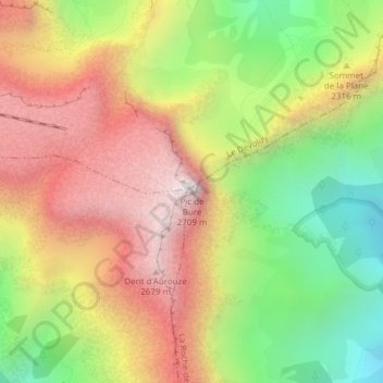
Name: Pic de Bure topographic map, elevation, terrain.
Average elevation: 2,122 m
Minimum elevation: 1,524 m
Maximum elevation: 2,706 m
Make a donation
Gear up for your next adventure:
As an Amazon Associate, this site earns from qualifying purchases at no extra cost to you.