Geolocate

Paese topographic map

Click on the map to display elevation.

About this map

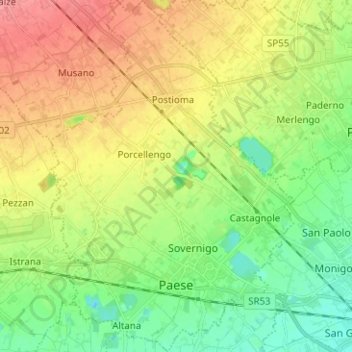
Name: Paese topographic map, elevation, terrain.

Location: Paese, Treviso, Veneto, 31038, Italy (45.65619 12.10869 45.74374 12.19591)

Average elevation: 42 m

Minimum elevation: 11 m

Maximum elevation: 82 m

Other topographic maps

Click on a map to view its topography, its elevation and its terrain.

Fanzolo

Italy > Veneto > Treviso > Vedelago

Average elevation: 60 m

Gear up for your next adventure:

🧦Outdoor Socks - Durable socks designed for hiking and outdoor sports
🔨Vehicle Emergency Tool - Safety tool for remote road trips to trailheads
👖Convertible Hiking Pants - Zip-off legs to adapt to changing weather conditions
🚲Handlebar Phone Mount - View topographic-map.com live while cycling
🥾Hiking Leggings - Comfortable leggings for outdoor activities

As an Amazon Associate, this site earns from qualifying purchases at no extra cost to you.