
Jauja topographic map
Interactive map
Click on the map to display elevation.
About this map
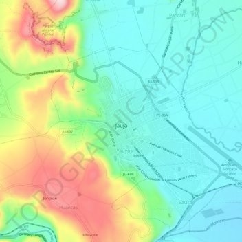
Name: Jauja topographic map, elevation, terrain.
Location: Jauja, Junín, Peru (-11.79214 -75.51723 -11.75637 -75.45798)
Average elevation: 3,441 m
Minimum elevation: 3,342 m
Maximum elevation: 3,653 m
Other topographic maps
Click on a map to view its topography, its elevation and its terrain.
Palio
Peru > Junín > San Juan de Jarpa
Palio, San Juan de Jarpa, Chupaca, Junín, Peru
Average elevation: 3,940 m
San Martín de Pangoa
San Martín de Pangoa, Pangoa, Satipo, Junín, Peru
Average elevation: 831 m