
La Merced topographic map
Interactive map
Click on the map to display elevation.
About this map
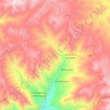
Name: La Merced topographic map, elevation, terrain.
Location: La Merced, Aija, Ancash, Peru (-9.77419 -77.69861 -9.62083 -77.53880)
Average elevation: 4,166 m
Minimum elevation: 3,048 m
Maximum elevation: 4,858 m
Other topographic maps
Click on a map to view its topography, its elevation and its terrain.
Kordilleren
Peru > Ancash > San Miguel de Aco
Kordilleren, San Miguel de Aco, Carhuaz, Ancash, Peru
Average elevation: 4,791 m
Uquia
Peru > Ancash > Independencia
Uquia, Independencia, Huaraz, Ancash, 02002, Peru
Average elevation: 3,431 m
San Antonio de Potrero
San Antonio de Potrero, Huachis, Huari, Ancash, Peru
Average elevation: 3,630 m
Independencia
Peru > Ancash > Independencia
Independencia, Huaraz, Ancash, Peru
Average elevation: 4,096 m
Alpamayo
Peru > Ancash > Santa Cruz
Alpamayo, Santa Cruz, Huaylas, Ancash, Peru
Average elevation: 5,210 m