Geolocate

Pebmarsh topographic map

Click on the map to display elevation.

About this map

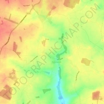
Name: Pebmarsh topographic map, elevation, terrain.

Location: Pebmarsh, Braintree, Essex, England, United Kingdom (51.95349 0.66621 51.98928 0.72528)

Average elevation: 71 m

Minimum elevation: 39 m

Maximum elevation: 89 m

Other topographic maps

Click on a map to view its topography, its elevation and its terrain.

Ashen

United Kingdom > England > Braintree > Ashen

Average elevation: 72 m

Doe's Corner

United Kingdom > England > Braintree > Doe's Corner

Average elevation: 24 m

Gear up for your next adventure:

🍽️Titanium Camping Spork - Ultralight and indestructible eating utensil
🧼Travel Hand Sanitizer - Keep hands clean when water is scarce
🛶Kayak Accessories - Essential gear for safe and fun kayaking adventures
🧥Ultralight Puffy Jacket - Maximum warmth that packs down to the size of an orange
🥾Waterproof Hiking Boots - Essential footwear for rugged terrain and wet Canadian trails

As an Amazon Associate, this site earns from qualifying purchases at no extra cost to you.