
Drakia topographic map
Click on the map to display elevation.
About this map
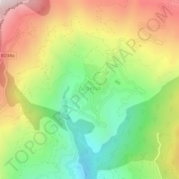
Name: Drakia topographic map, elevation, terrain.
Average elevation: 640 m
Minimum elevation: 233 m
Maximum elevation: 1,138 m
Other topographic maps
Click on a map to view its topography, its elevation and its terrain.
Lake Karla
Greece > Thessaly and Central Greece > Regional Unit of Magnesia > Municipal Unit of Karla
After draining, site included Mavrovouni Mountain, two water reservoirs in former Lake Karla and the spring Kefalovryso in Velestino. Mavrovouni (390 km2 or 96,000 acres, max elevation 1,054 m or 3,458 ft) extends between Ossa and Pilio mountains and was restored totally in Magnesia. It mainly consists of…
Average elevation: 103 m
Volos Municipality
Greece > Thessaly and Central Greece > Regional Unit of Magnesia
Average elevation: 228 m
Argalasti
Greece > Thessaly and Central Greece > Regional Unit of Magnesia > Municipal unit of Argalasti
Average elevation: 226 m
Mouresi
Greece > Thessaly and Central Greece > Regional Unit of Magnesia > Municipal Unit of Mouresi
Average elevation: 303 m
Agios Ioannis
Greece > Thessaly and Central Greece > Regional Unit of Magnesia > Volos Municipality > Portaria
Average elevation: 815 m
Municipal Unit of Karla
Greece > Thessaly and Central Greece > Regional Unit of Magnesia
Average elevation: 212 m
Makrinitsa
Greece > Thessaly and Central Greece > Regional Unit of Magnesia > Volos Municipality
Average elevation: 663 m
Milina
Greece > Thessaly and Central Greece > Regional Unit of Magnesia > Sipias Municipal Unit
Average elevation: 81 m
Kissos
Greece > Thessaly and Central Greece > Regional Unit of Magnesia > Municipal Unit of Mouresi
Average elevation: 482 m
Δημητριάδα
Greece > Thessaly and Central Greece > Regional Unit of Magnesia > Volos Municipality
Average elevation: 3 m
Χάνια
Greece > Thessaly and Central Greece > Regional Unit of Magnesia > Volos Municipality
Average elevation: 1,103 m
Σούρπη
Greece > Thessaly and Central Greece > Regional Unit of Magnesia > Municipal Unit of Sourpi
Average elevation: 123 m
Ano Volos
Greece > Thessaly and Central Greece > Regional Unit of Magnesia > Volos Municipality
Average elevation: 289 m