
Fügenberg topographic map
Interactive map
Click on the map to display elevation.
About this map
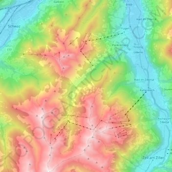
Name: Fügenberg topographic map, elevation, terrain.
Location: Fügenberg, Bezirk Schwaz, 6264, Autriche (47.22125 11.74306 47.36677 11.84950)
Average elevation: 1,366 m
Minimum elevation: 526 m
Maximum elevation: 2,553 m
Other topographic maps
Click on a map to view its topography, its elevation and its terrain.
Pertisau
Autriche > Bezirk Schwaz > Eben am Achensee
Pertisau, Eben am Achensee, Bezirk Schwaz, Tyrol, 6213, Autriche
Average elevation: 1,141 m
Maurach
Autriche > Bezirk Schwaz > Eben am Achensee
Maurach, Eben am Achensee, Bezirk Schwaz, 6212, Autriche
Average elevation: 1,197 m
Eben am Achensee
Eben am Achensee, Bezirk Schwaz, Autriche
Average elevation: 1,401 m